Mission Bay, San Francisco
Mission Bay covers 1.0 square miles of San Francisco, and about 11,210 people live here. This page maps 64 parks and public places and 10 businesses inside its lines, most of them Food and Drink.

Living In Mission Bay
Mission Bay has about 11,210 people on 1.0 square miles, 11,244 per square mile, denser than San Francisco as a whole (3,582).
The median household earns $211,840 a year, 50% above the city median, #9 of 75 neighborhoods.
68% of homes are rented, and the median rent is $3,501 a month.
It is still growing: 59% of homes were built in 2010 or later.
People here skew younger, with a median age of 32 against 40 citywide.
20% of workers walk to work, against 9% across San Francisco.
95% of homes have broadband internet.
Inside its lines: 16 piers, 12 parks, 5 transit stops, 4 police stations and 4 places to eat.
People
Money And Work
Housing
Getting Around
Connected
US Census Bureau American Community Survey 2020 to 2024, added up from the census tracts in Mission Bay. Ranks count neighborhoods with 500 or more people.
Parks, Schools And Public Places In Mission Bay
Piers 16
- Dock A
- Dock B
- Dock C
- Dock D
- Dock E
- Dock F
- Dock G
- Fishing Pier
- North Guest Dock
- Oracle Park
- Pier 48
- Pier 48.5 (Chase Center Ferry Terminal)
4 more on the map below
Parks 12
- Bayfront Park
- China Basin Park
- Daggett Park
- F.A.R.M.
- Koret Quad
- Mission Bay Commons
- Mission Bay Kids Park
- Mission Creek Park
- Mission Creek Park
- Parklab
- South Beach Park
- UCSF Mission Bay ParkGene Friend Way, San Francisco, CA 94158
Transit Stops 5
 Mission Rock
- 2nd & King
- Oracle Park Ferry Terminal
- San Francisco Pier 48.5 (Chase Center Ferry Terminal)
- UCSF/Chase Center
Police Stations 4
- Campus Police Office
- SFPD Headquarters1245 3rd Street, San Francisco, CA 94158
- SFPD Southern Police Station1251 3rd Street, San Francisco, CA 94158
- Transit Police Bureau SFK Substation
Clinics 3
- Kaiser Permanente Mission Bay1600 Owens Street, San Francisco, CA 94158
- One Medical
- Saint Francis Health Center
Landmarks And Historic Sites 3
- Historic Fire Station #301275 3rd Street, San Francisco, CA 94158
- The Garcia & Maggini Warehouse
- Whaling Out of San Francisco
Schools 3
- Hiba Academy Bay Area
- Mission Bay School1415 Owens Street, San Francisco, CA 94158
- The Dahlia School1245 4th Street
Sports Fields 3
 Chase Center1 Warriors Way, San Francisco, CA 94158
 Oracle Park24 Willie Mays Plaza, San Francisco, CA 94107
- SFF Soccer
Dog Parks 2
- Daggett Plaza Dog Run
- Mission Bay Dog Park
Fire Stations 2
- San Francisco Fire Station 29299 Vermont Street, San Francisco, CA 94103
- San Francisco Fire Station 4449 Mission Rock Street, San Francisco, CA 94158
Museums 2
- CCA Wattis Institute for Contemporary Arts145 Hooper Street, San Francisco, CA 94107
- Misalignment Museum1699 3rd Street, San Francisco, CA 94158
Playgrounds 2
- Mission Bay Kids Park Playground
- South Beach Playground
Arts Centers 1
- San Francisco Center for the Book (SFCB)375 Rhode Island Street, San Francisco, CA 94103
Community Centers 1
- 826 Valencia Mission Bay1310 4th Street
Libraries 1
- Simpson Library
Marinas 1
Trails And Bike Paths 1
- McCovey Cove Promenade
Places To Go In Mission Bay
The most reviewed spots inside these lines, with photos where they have one.
Businesses In Mission Bay
Is yours missing or wrong? List or fix it free.
Food and Drink 4
 Dumpling Time Design DistrictDumpling restaurant
 ATWater TavernCalifornian restaurant
 Cafe RéveilleCafe
 SPARK Social SFFood court
Parks and Recreation 2
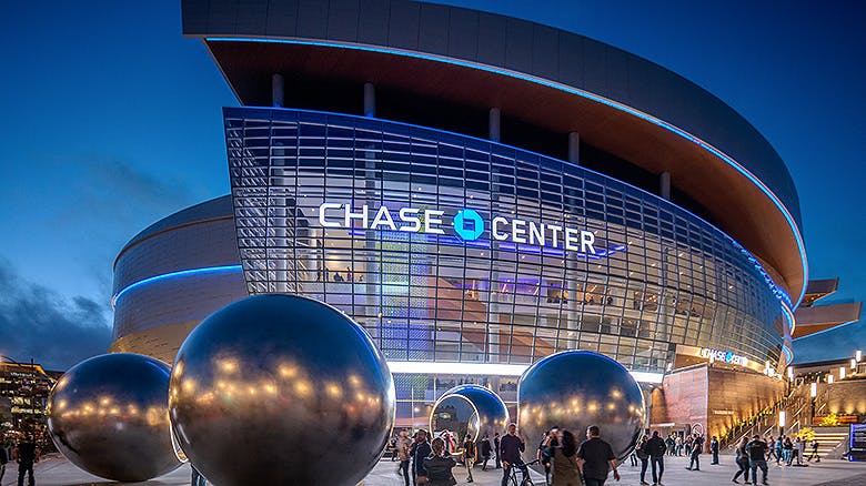 Chase CenterArena
- Oracle ParkStadium
Moving and Storage 1

Auto 1
 Bring a TrailerAuto auction
Lodging 1
 Hotel VIAHotel
Health and Medical 1
 Concentra Urgent CareOccupational health service
Own A Business In San Francisco
List it free on your neighborhood page in about two minutes. Townstoop is built by Clickflame, building local business sites since 2004.
Mission Bay Questions
How many people live in Mission Bay
About 11,210, from the Census American Community Survey tracts inside the Mission Bay lines.
What parks are in Mission Bay
12 mapped, including Bayfront Park, China Basin Park, Daggett Park, F.A.R.M..
How many schools are in Mission Bay
3 schools are mapped inside the neighborhood.
What is the rent like in Mission Bay
The Census median gross rent is $3,501 a month, against $2,476 for all of San Francisco.
Do people rent or own in Mission Bay
68% of homes are rented and 32% are owned, against 62% rented across San Francisco.
How do people get to work from Mission Bay
The average commute is 28 minutes. 21% drive alone, 16% take transit, 20% walk and 32% work from home.
How old are the homes in Mission Bay
2% were built before 1960 and 59% in 2010 or later. 3% are single family homes.
Is Mission Bay a family neighborhood
17% of households have children and 14% of residents are under 18. 8% are 65 or older.
Sources, Census figures from the US Census Bureau American Community Survey five year estimates, parks, schools and public places from OpenStreetMap contributors (ODbL). How we build these pages.